Tagapo: A mountain in an island
There are times that almost everything just gets in your nerves. That's the sign that you need a time off, away from the bustles of your fast-paced existence. It's time to go somewhere isolated, where you can stretch your cramped muscles and make your heart race.
Now, the question is, where can we find such place? The answer: Mt. Tagapo
Mt. Tagapo, or to quote Jose Rizal, "Susong Dalaga", is located in the island of Talim in Laguna de Baie. Compared with other mountains in CALABARZON, it is less crowded with climbers.
This mountain offers a very different experience as you have to ride a barge for an hour to reach the jump off. Enjoy the stunning view of Laguna de Baie and the city lights of nearby Metro Manila.
Mt. Tagapo is located in Talim Island, the largest island in Laguna de Baie. It is within the municipality of Binangonan, Rizal, about 33 KM south of Metro Manila.
The Team
The date of the climb was February 18, 2017, Saturday. There are only two of us in the climb party.
Now, the question is, where can we find such place? The answer: Mt. Tagapo
Mt. Tagapo, or to quote Jose Rizal, "Susong Dalaga", is located in the island of Talim in Laguna de Baie. Compared with other mountains in CALABARZON, it is less crowded with climbers.
This mountain offers a very different experience as you have to ride a barge for an hour to reach the jump off. Enjoy the stunning view of Laguna de Baie and the city lights of nearby Metro Manila.
Background
Jumpoff point: Brgy. Janosa, Binangonan, Rizal
Trail Difficulty: 2/9
Height: 438+ MASL
Trail Class: 1 - 2
Height: 438+ MASL
Trail Class: 1 - 2
Guide: Required, P500 for dayhike, P800 for overnight
Beginner Friendly? Definitely!
Beginner Friendly? Definitely!
Mt. Tagapo is located in Talim Island, the largest island in Laguna de Baie. It is within the municipality of Binangonan, Rizal, about 33 KM south of Metro Manila.
The Team
 |
| Pearly and Iantot, the Princess and the Pauper |
HOW TO GET THERE
 |
| Barge Ride to Brgy. Janossa |
- Go to Starmall, Shaw Boulevard
- From Shaw Boulevard, ride a jeepney going to Binangonan, Travel time 1 - 1.5 hours, fare P35.00
- Alight at Binangonan Port
- From Binangonan Port, ride a barge going to Brgy. Janosa, Travel time 45 min - 1 hr, fare P30
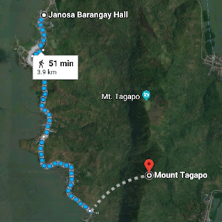
- Register at the barangay hall and secure a guide
Note: The barge ride is not really long. However, the travel time is usually lenghtened due to numerous stopovers to different barangays in Talim Island. You can opt to alight in the very first barangay then ride a tricycle to Brgy. Janossa. However, we recommend you to choose the first option to have a fuller experience.
 |
| Barangay Hall, jump-off point to Mt. Tagapo |
The initial part of the trail cuts through residential area. You will pass by the elementary school and the community clinic on the way to the trail head. As of the writing of this blogpost, hiring a guide is now required. (See Background). This segment is cemented and will be only a small portion of the climb. After 10 - 15 minutes, you will reach the end of the cemented path and the real climb begins.
The trail is mostly gentle ascent through a wooded area. From Brgy. Janosa, it will take you about 1.5 - 2 hours to reach the summit of Mt. Tagapo. Majority of the trail leading to the main campsite is shaded so no worries of getting sunburned
The first sign that you are halfway through is the big mango tree. Here, you can take a breather and maybe a quickbite. In our case, we decided to continue on since it was already 8PM when we arrived at the mango tree and the sky decided to bless us with too much rain.
The second part of the trail is a grassland. Reaching the grassland means that the main campsite is just 10 - 15 minutes away. The main campsite is a bit narrow as it can only accommodate 3 - 5 tents at a time.
We immediately pitched our tent and prepared our dinner upon arrival. The thunderstorm was gaining momentum so we have to be fast.


Thank you for sharing your adventure with great details, really helpful and informative! ☺️ Planning to do an overnight and camp out as well to see the sunrise. Did you share your tent with the guide?
ReplyDelete